Photo adventure in Zagori – Greece
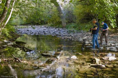
Perhaps you’re wondering, looking at this photo below, why those two crazy people are running into the water with a tripod? Of course, it was all about achieving the perfect composition and for this, adventurous photographers try everything without compromise. If you keep reading, you’ll find out what happened and have a look at the resulting photo.
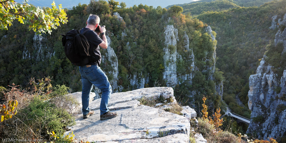
This year, the Adventure Class met in the mountains of northern Greece in October to go on photo adventure tours with me for a week. Previously, we had traveled together in Greece on canyon adventures (2022) and volcano adventures (2023), and in Sardinia on cave and cliff adventures (2024). This time, I had prepared the photo topic rivers and canyons for them.
The Destination
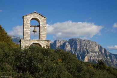
Our destination, Zagori, can be defined geographically, historically, in terms of its natural environment, or administratively. Depending on the definition used, Zagori will be more or less narrowly defined. Geographically, it is located in the northwestern Greek region of Epirus, between the cities of Ioannina to the south, Konitsa to the north, and Metsovo to the southeast. In 2023, Zagori was designated a UNESCO World Heritage Site.
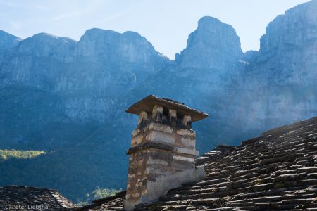
The Zagori villages are characterized by their massive grey houses built from local stone, grey stone roofs, narrow cobblestone streets and stone arch bridges.
Vikos-Aoos National Park
A large part of Zagori is protected as the Vikos-Aoos National Park. The park covers an area of approximately 126 square kilometers. It was established in 1973. Rare and endemic plants, such as the Greek peony and the Epirus violet, thrive in the park, along with a rich fauna, including brown bears. The park’s geological highlights are the Vikos Gorge and the Aoos Gorge, which were carved by the Aoos and Voidomatis rivers a long time ago.
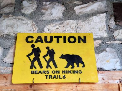
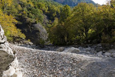
Photo destination Voidomatis
Our first destination was the Voidomatis Trail, which was within walking distance of our hotel. The trail features 14 information panels detailing the life and activity of the nomadic hunters who roamed this area with bows and arrows between 17,500 to 9,500 years ago.
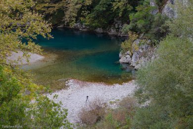
The Voidomatis Trail is 4 kilometers long, and the estimated time for this route is given as 2.5 hours. But not with us! Anyone wanting to take serious photos will hardly make any progress on the path. Mighty, bizarrely shaped plane trees line the banks. Some stand half-submerged. In some places, the water shimmers in rich shades of blue. After the next bend, the autumn leaves of the plane trees are reflected, casting a golden glow on the water’s surface.
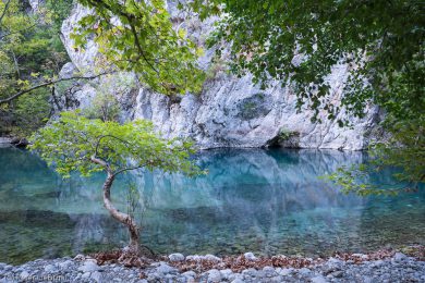
How can the vibrant blue of the water be captured?
After a first review of the day’s photos, we weren’t entirely satisfied. We hadn’t always managed to capture the color mood, so obvious to the naked eye. How do you capture the vibrant blue of the water with a camera? Theoretically, we knew that it had something to do with perspective, with the angle from which the camera viewed the water. And, of course, with the time of day and the quality of the light. Luckily, our hotel was close to the river. This allowed us to spontaneously go back to the river a second and third time. We could study the effect at different times of day and in different light conditions to improve our technique. In the end, the photos taken at dusk with the last light of day were the most interesting for us.
Overall, we felt very comfortable at our Hotel Spiridoula in Klidonia. The peaceful location close to the river was ideal; in the evenings, we could reflect on the day over an Alpha beer and in the mornings, Spiridoula provided us with a delicious breakfast to fuel our adventures. Ralf put it this way: “Nice people, good food, a beautiful hotel, and a magnificent landscape – once again, I felt welcome in Greece.”
Torsten summarizes it in a broader context: “Once again, we were able to enjoy the impressive and pristine, gorge-covered mountain landscape of the Pindus Mountains and try to capture the autumn-colored rivers in photographs during our hikes. Due to the sparse population in small villages and its remoteness from the usual tourist crowds, this southern part of the Balkans is still a gem for nature lovers and will likely remain so for some time, which leaves room for traditional dishes, village scenes, taverns under plane trees, and handicrafts. We thoroughly enjoyed these days outdoors and in our welcoming and spacious family hotel.”
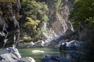
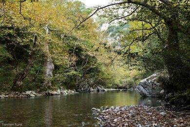
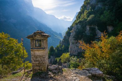
Photo destination: Aoos Gorge
The Aoos River originates in the eastern Pindus Mountains and forms the northern border of Zagori. Ten kilometers before Konitsa, two million years ago, the river squeezed between the Tymfi and Trapezitsa mountains, creating the Aoos Gorge. From there, the river widens into the Konitsa Plain, where it joins the Voidomatis River and flows through Albania into the Adriatic Sea.
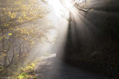
On the southern bank of the river, a 5-kilometer trail begins at the large stone arch bridge in Konitsa, leading through the gradually narrowing gorge. The hike captivated us right from the start with rising mist, broken by the sun. There are frequent access points to the water and the gravel banks. The endpoint is the Panagia Stomiou Monastery, perched on a hill above the valley. The estimated hiking time to the monastery is 2.5 to 3 hours. However, this proved completely unrealistic for us, as the river and the gorge offered new photo opportunities every few steps. We never actually reached the monastery!
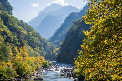
Photo destination Vikos Gorge
An information panel states that the Vikos Gorge is 900 meters deep. However, depending on the source, the reported maximum depth of the gorge varies between 600 and 1000 meters. We were able to experience what it feels like to look down into such a deep gorge from above, on the edge of the village of Vikos. This small village, situated at an altitude of 770 meters, offers spectacular viewpoints overlooking the gorge. A path is supposed to lead us down to the Voidomatis springs.
But what a surprise: the riverbed was completely dry. The bright blue spring water that I had photographed there at the same time of year in previous years had vanished. The dynamic shapes along the empty riverbed gave us an intense impression of the power that the water had once unleashed there.
The visual experience of gazing into the deep Vikos Gorge is breathtaking, but capturing it photographically is challenging. Ralf describes it this way: “The hikes over mountains and through gorges were strenuous, but manageable – the real challenge for me this time was the photography. In the gorges, I often found the lighting conditions quite difficult, with low light or extreme contrasts. And at higher altitudes, the views were almost impossible to take in with the naked eye. So I often asked myself how to take a photo that could at least partially convey this magnificent impression to the viewer, because that’s ultimately my goal.”
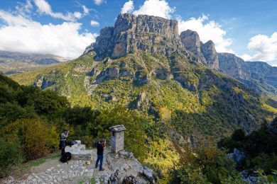
Ralf succinctly summarizes our dilemma with light and perspective. One strategy was to work with different focal lengths on location. The two photos above this paragraph – taken from the same spot – provide an example. I also sometimes find it helpful to include people in the picture to convey a sense of scale and depth.
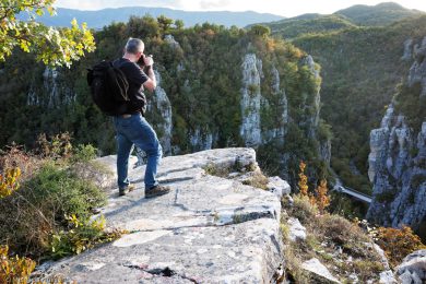
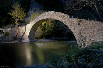
Photo destination: arched bridges
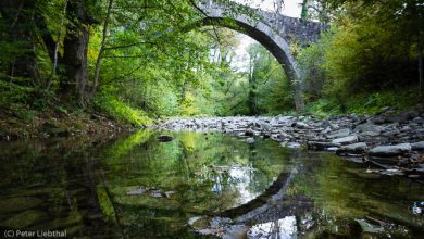
The stone arch bridges are among the most impressive examples of traditional building and craftsmanship in the region. Fifty-three arch bridges have been counted; the most famous include the bridge over the Aoos River near Konitsa (1871), the bridge over the Voidomatis River near Klidonia (1853), and the three-arched Kalogeriko Bridge (1814) near Kipi. The Petsioni Bridge (1830), at the edge of Kipi is nestled in lush green vegetation, which gives it an almost magical quality. This impression is doubled in the photo when the reflection in the water is also captured.
The following information is taken from an information panel in front of the Kalogeriko Bridge: The builders from Epirus were famous throughout Greece and beyond. Those who specialized themselves and their teams in bridge construction were called Kioproulides, meaning “bridge people.” At the head of a bridge-building team was the Protomastoras, the architect responsible for the bridge’s design. Next in the team hierarchy were the master stonemasons and carpenters; they supervised the team members who fitted the stones together. Construction began from both sides, and the bridge was completed when the final central stone, the keystone, could be placed at the highest point.

The Konitsa Bridge
From our hotel, Spiridoula, we quickly reached Konitsa, the nearest town with shops, bakeries, and a good selection of tavernas. An information panel describes the stone bridge in Konitsa as one of the largest single-arch bridges in the Balkans. It spans the Aoos River at the entrance to the Aoos Gorge since 1871. The people in the photos are shown in relation to the bridge’s 20-meter height and 40-meter span.
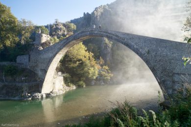
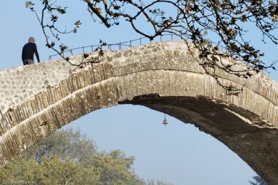
In the middle of the arch, we discovered a small bell. The information panel explains its purpose: it rings when there is a strong wind, warning people that crossing the bridge is dangerous. The view of the gorge in the background makes the bridge a captivating subject for photography both during the day and at blue hour. Our blue hour photo session was enhanced by a group of passing bikers who rushed into the river for a quick dip. The reflection of the bridge in the water didn’t get distorted, however, as the water was so cold that they were back out again very quickly.
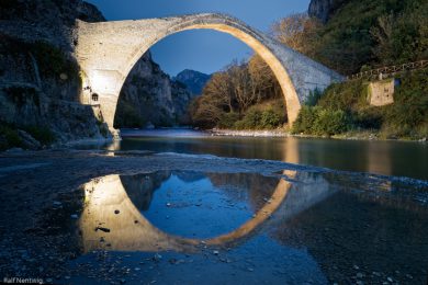
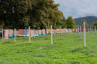
Photo destination Nerotrivi
In the water-rich Pindus Mountains, many water-powered mills dotted the rivers. The history of Zagori’s stone arch bridges is intertwined with that of these watermills. Operators and customers alike relied on the bridges, as they provided access to the mills. “Every year, when the weather warms up and the rain stops, we bring the carpets to the Nerotrivi.” This is how a report on Naturally Zagori begins , describing this ancient tradition in Greece, and especially in the water-rich region of Epirus.
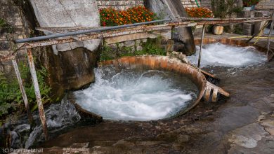
The Nerotrivi is a fulling mill, which, in conjunction with a whirlpool-like water basin, is also used for carpet care. On the outskirts of Kalpaki, we combined a visit to the Nerotrivi restaurant with a Nerotrivi photo session. Colorful carpets hung out dryinglooked like splashes of paint in the landscape.
In addition to cleaning carpets and blankets, the fulling mill often also houses a grain mill and a trout farm, according to the report quoted above. We can confirm the bit about the trout after visiting the Nerotrivi restaurant :-).
Summary
Zagori is a part of Greece with much to discover. The traditional stone villages, numerous monasteries, bridges, and historic paths attest to the region’s long history and artisanal traditions. We didn’t notice any damage caused by over-tourism (tread erosion, litter, traffic congestion). Instead, we found many well-marked hiking trails, with information panels at the trailheads providing details about the bridges, flora, fauna, geology, and history of the region.
Peter summarizes his impressions as follows: “The Adventure Class – a highlight every year. Exploring unfamiliar landscapes off the beaten tourist track and capturing their unique features photographically is an exciting challenge. Many thanks to you, dear Michaela, for the week in Zagorochoria.” Ralf sums up his experience: “Thanks to Michaela’s excellent preparation, we made the most of our time and the weather. I definitely had a lot of fun, and a wide variety of photos were taken. Perhaps it wasn’t quite as ‘adventurous’ as in previous years, but for me, it was a thoroughly successful week of photography.”
Finally, here’s a photo gallery showcasing some of the results from this year’s Adventure Class. We’d love to hear your comments!
Click a preview image for fullscreen view
Show Comments >>